
Note from Will Brownsberger: The DCR Parkways Master Plan is a long-term, aspirational vision as opposed to a vetted work plan. It creates a context for discussion of individual projects, but does not control decisions about individual projects. Each project implementing the master plan will still be subject to the normal approval process, including public input.
This post contains relevant excerpts from the DCR Parkways Master Plan about the projects happening in the district. To view more details on these projects, you can read the full report here.
Table of Contents
- Study Area
- What This Plan Does
- Focus Area 6: Charles River Basin West
- Focus Area 9: Back Bay Fens
- Focus Area 10: Chestnut Hill
- Conclusion
- Next Steps
Study Area- Page 2
“This Plan focuses on a group of parkways that span the metropolitan Boston region. Although several parkways in this Plan are part of other ongoing studies, the vast majority have not been subject to detailed planning or analysis in recent years. Many have not been recently worked on or upgraded, and thus represent key opportunities to be modernized to current standards for pedestrian and bicycle accommodations and roadway geometry. Importantly, they all serve key regional destinations for both recreational and transportation purposes. Parkways that are being studied as part of a stand-alone effort and those with existing facilities for nonmotorized users are not included in this Plan.”
What This Plan Does – Page 5
“The Parkways Master Plan develops short- and long-term recommendations for each parkway in the study area. Short-term improvements include all elements that can be fixed or updated as part of DCR’s repaving program (e.g., new bike lanes, crosswalks, ramps), or as a standalone project initiative on the parkways such as a comprehensive curb ramp program, a new crosswalk, repainting of key markings like bike lanes or crosswalks, updated crossing signals and parkway lighting. Longterm improvements include the opportunities that may exist for each parkway if newly designed for full reconstruction to bring the parkway into complete streets and full ADA compliance. Such design plans will often include a road diet (lane reduction), new off road, grade separated bicycle and pedestrian facilities, major improvements to the overall accessibility for all nonmotorized users, relocated curbs, new drainage, new lighting and new crossings and signals. These are highcost, high-profile projects that will take many years to implement fully.
DCR will continue to engage in on-going dialogue with stakeholders and advocates, such as the UPPC and MAPC, affected communities, and the general public. The extensive data collected for each parkway in this Plan and existing regional greenway plans will help guide the dialogue in selecting those projects with the greatest benefit to overall pedestrian/bicycle connectivity, public safety enhancements, and improved accessibility for the general public.”
Focus Area 6: Charles River Basin West – Page 154
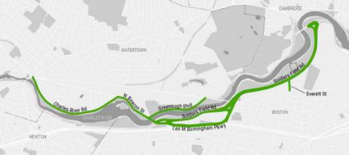
Charles River Road
Issue 1: From Watertown Square to North Beacon Street, there is a narrow shared use path and bike lanes need improvement. Recommendation: “As a short-term measure, consider alternatives to widen the existing bike lanes. Long-term, upgrade the existing sidewalk to a wide shared use path (10 to 12 ft. in width). “
Issue 2: From Beechwood Ave to North Beacon Street, there is a pedestrian connectivity gap. Recommendation: Construct a continuous sidewalk along the northern side of the parkway, and provide new crosswalks at Pequossette Street and Palmer Street.
Issue 3: At the intersection of North Beacon Street, there are long crossing distances, bicycle navigation and wayfinding issues, and a narrow shared use path. Recommendations: Improve intersection geometry to better accommodate pedestrians and bicyclists, and consider installing a protected intersection to improve safety for bicyclists traveling through the intersection.
Issue 4: In Watertown Square, there is a lack of pedestrian and bicycle connectivity, a narrow shared use path, and it is a high crash location. Recommendations: “Modify the Watertown Square intersection in conjunction with the Charles River Road/Riverside Street realignment proposed by AthenaHealth.”
Reimagining Charles River Road: “It is recommended that DCR consider the feasibility of closing Charles River Road to through traffic to restore the river edge parkland as passive recreational space. Removing through traffic would allow for the expansion of valuable riverfront parkland and an enhanced recreational and transportation corridor for non-motorized users. Maintaining vehicle access to parking areas (including the Watertown Riverfront Park and Braille Trail), residences, and institutional destinations would be an important part of such a project. From the east, vehicle access could be maintained up to at least Beechwood Ave. On the western end, access could be maintained at least between Irving Street and Wheeler Lane. Access to the Perkins School for the Blind parking lot would be provided from either the east or west side.”
North Beacon Street
Issue 1: From Charles River Road to Greenough Boulevard, there is a lack of regional trail connectivity, the existing bicycle facilities need improvement, and there are wide travel lanes. Recommendation: “As a short-term measure, install one-way separated bike lanes on both sides. Consider the following longer-term alternatives to improve pedestrian and bicycle facilities:
- Build a two-way separated bike lane and parallel sidewalk along the river side of the parkway. Additionally, provide a westbound bicycle facility on the north side of the parkway for bicyclists continuing west on North Beacon Street past School Street.
- Construct one-way separated bike lanes on both sides of the parkway.”
Issue 2: At the intersection of Greenough Boulevard, there are long crossing distances and a potential node in regional trail network with the proposed connection to the Watertown Greenway via Talcott Ave. Recommendation: Modify the intersection to improve safety and connectivity for all users, and consider signalization and the addition of pedestrian crossing islands.
Issue 3: On North Beacon Street Bridge (over the Charles River) there are no bicycle accommodations. Recommendation: “As a short-term measure, install bike lanes. Long-term, consider the feasibility of widening the sidewalks on both sides to accommodate pedestrians and two-way bicycle operations.”
Issue 4: At the intersections of Soldiers Field Road and Nonantum Road, Paul Dudley White Bike Path crossing at North Beacon Street needs improvement, there is no pedestrian and bicycle access from North Beacon Street bridge to south side of North Beacon Street, there are narrow paths approaching the intersection, and there is a general lack of accessibility. Recommendation: “Consider the following modifications to the intersection:
- Taper the westbound approach to the bridge to one travel lane and consider providing a signal or beacon to encourage vehicle yielding to path users. In conjunction, widen the approaching path segment and buffer and extend the curb at the corner.
- Add a new shared use crossing between the northwest corner of the intersection and the DCRowned swimming pool building on the south side of North Beacon Street.
- Explore opportunities to widen the path approaching North Beacon Street from the west.”
Issue 5: At the intersection of Parsons Street, there are accessibility issues, and there is no pedestrian and bicycle access route from Parsons Street to the Paul Dudley White Bike Path. Recommendation: “Add a shared use crossing between the southeast corner of and the Paul Dudley White Bike Path along the eastern edge of the intersection.”
Issue: From Soldiers Field Road to Leo Birmingham Parkway, there is a sidewalk connectivity gap on the south side east of Parsons Street, and there are no bicycle accommodations. Recommendation: “As a short-term measure, extend the sidewalk eastward from Parsons Street to Leo Birmingham Parkway. Along the southern edge of North Beacon Street, consider constructing a shared use path as part of longer term reconstruction.”
Birmingham Parkway
Issue 1: At the intersection of North Beacon Street, this is a crash hot spot, there are no pedestrian crossings, there are no bicycle accommodations, and there is the opportunity to improve access to riverfront park system from residential neighborhoods south of Interstate 90. Recommendation: “Modify the intersection geometry to address common crash types, and add crosswalks, sidewalks, and bicycle facilities.”
Issue 2: From North Beacon Street to Market Street, there is a sidewalk connectivity gap, and there are no bicycle accommodations. Recommendation: “As a short-term measure, install buffered bike lanes on both sides and remove a travel lane on both sides. Build a sidewalk along the northern side of the parkway. Longer-term, consider consolidating all vehicle traffic to one side of the median and convert the other side to a shared use path.”
Issue 3: At the intersection of Market Street and Lincoln Street, there are long crossing distances, additional crosswalks are needed, and there are no bicycle accommodations. Recommendation: “Reduce corner radii and provide crosswalks across all intersection approaches. Consider all design changes in conjunction with the proposed Birmingham Parkway road diet west of the intersection and the proposed Lincoln Street bikeway (People’s Pike Path).”
Issue 4: From Market Street to Western Ave, there are no bicycle accommodations, and the pedestrian and bicycle access between riverfront park system and nearby neighborhoods needs improvement. Recommendation: “Construct one-way separated bike lanes on Birmingham Parkway between Western Avenue and Lincoln Street.”
Issue 5: At the intersection of Lothrop Street, pedestrian and bicycle access across parkway needs improvement. Recommendation: “Provide a shared use crossing across Birmingham Parkway at Lothrop Street.”
Issue 6: At the intersection of Western Avenue and Arsenal Street, recent improvements made at approach to Arsenal Street Bridge include a widened crossing, curb extensions, and new signals. Additionally, pedestrian and bicycle access to Paul Dudley White Bike Path from Leo Birmingham Parkway needs additional improvement. Recommendation: “As a short-term measure, add sidewalks and crosswalks along the southern side of Western Avenue. Consider pavement markings to guide bicyclists through the intersection. Longer-term, consider comprehensive changes to reduce the overall intersection footprint, shorten crossing distances, and reduce pedestrian and bicycle delay. “
Reimagining Leo Birmingham Parkway: “Between North Beacon Street and Market Street, existing traffic volumes are relatively low, while currently no formal pedestrian and bicycle accommodations are provided. Regional traffic demand is served by adjacent corridors, including Soldiers Field Road, North Beacon Street, and Interstate 90. It is recommended that DCR consider the feasibility of closing this segment of Birmingham Parkway to vehicle traffic. The parkway can be restored to parkland with through access for non-motorized users. Recreational facilities could be added, such as playing fields, skate park, or an open-air restaurant. At its eastern end, the parkway could connect the greenway along Lincoln Street envisioned by community residents.”
Soldiers Field Road
Issue 1: From Eliot Bridge to Western Ave, there are wide travel lanes. Recommendations: “Restripe Soldiers Field Road with narrower travel lanes (10.5 to 11 feet recommended).”
Issue 2: From North Beacon Street to Birmingham Parkway, the pedestrian and bicycle access along the south side of the Soldiers Field Road needs improvement, and the existing path is narrow. Recommendation: “Widen the Paul Dudley White Bike Path to 12 to 15 feet where feasible. On the south side of Soldiers Field Road, consider reconstructing the existing sidewalk as a shared use path to provide access to existing retail destinations. The path would extend along the eastbound ramp to Birmingham Parkway where a crossing would be provided to Lothrop Street. Consider additional safety measures, such as a road diet and or the addition of a median.”
Issue 3: At the intersection at Eliot Bridge, parkland is bisected by roadways. Recommendation: “Consider reconstructing the intersection of Soldiers Field Road and the Eliot Bridge as a modern roundabout. Alternatively, consider reconstructing the intersection with a significantly smaller footprint.”
Issue 4: At the intersection of Everett Street, pedestrian and bicycle access to Herter Park needs improvement. Recommendation: “Add crosswalks across Soldiers Field Road to improve pedestrian access to/from Everett Street.”
Issue 5: At the intersection of Telford Street, pedestrian and bicycle access to Herter Park needs improvement. Recommendation: “Reconstruct the existing pedestrian bridge over Soldier’s Field Road or remove bridge and replace with a new, at-grade crossing.”
Issue 6: Near 1120 Soldiers Field Road, pedestrian access between Herter Park and Smith Field needs improvement. Recommendation: “Consider the desirability of adding a new crossing in the vicinity of this location.”
Greenough Boulevard
Issue 1: Along the length of the corridor, existing shared use path needs improvement, regional path connectivity needs improvement, and the connection to existing Greenough Boulevard path north of Arsenal Street could be strengthened. Recommendations: “Upgrade the existing path along the river to a wide shared use path (10 to 12 ft. in width). Near the Arsenal Street intersection, route the path along the edge of the river following the existing natural surface path. This routing would connect the existing path on Greenough Boulevard north of Arsenal Street.”
Issue 2: At the Intersection of Arsenal Street, there is a crash history and a pedestrian and bicycle connectivity gap. Recommendations: “Consider alternatives to reduce conflicts between vehicles turning left from Arsenal Street westbound to Greenough Boulevard and left turning vehicles exiting Greenough Boulevard turning left onto Arsenal Street. Alternatives include:
- Restricting all left turns by installing a median.
- Adding a left turn lane on Arsenal Street westbound and restricting left turns out of Greenough Boulevard.
- Adding a signal.”
Focus Area 9: Back Bay Fens – Page 180
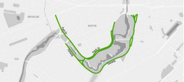
Park Drive – Segment 1 (Boylston Street to Higginson Circle Bridge)
Implemented Short-Term Modification: “Crosswalks are provided at intersecting streets and at some mid-block locations. This section was modified in the short-term from a two lane roadway to a one-way vehicle travel lane with a buffered bike lane with the direction of vehicle traffic. A shared use path runs parallel to the main roadway within the parkland… Bicyclists traveling west can use the bike lane while eastbound bicyclists use the existing shared use path. The short-term modification was integrated into existing traffic operations and minimal construction was required. However, eastbound bicyclists still share the path with pedestrians. Westbound bicyclists traveling towards Ave Louis Pasteur still need additional consideration in the Higginson Circle area.”
Long-Term Recommendation: Long-term, a two-way separated bike lane is recommended along the park side edge of the roadway implemented using striping and vertical separation. General travel lanes are reduced from two to one…The intersections of Boylston Street and Higginson Circle would require some construction. At a minimum, curb ramps could be provided to transition bicyclists onto existing shared use paths. However, additional reconstruction is recommended to provide separate pedestrian and bicycle spaces up to and through intersections. Two-way bicycle operations could be extended north from Higginson Circle to Brookline Ave.”
Park Drive Segment 2 (Higginson Circle bridge to Brookline Ave)
Implemented Short-Term Modification: “On the west side of Higgins Circle is the Muddy River, which recently underwent a large restoration project to daylight portions of the river and improve flood control…North of Peterborough Street, the road widens to feature additional turning lanes approaching Brookline Ave. No bicycle accommodations are provided in the roadway. Crosswalks are provided at intersecting streets. On the west side of the roadway, there is a stone dust path providing pedestrian access to the riverfront. This segment of Park Drive is a major north-south desire line for bicyclists. Short-term modifications were implemented as part of the Parkways Master Plan process with a standard bike lane in the direction of travel. There are no accommodations for southbound bicycle travel.”
Long-Term Recommendation: “A two-way separated bike lane is feasible along the park side edge of the roadway implemented using striping and vertical separation. This would be a continuation of the long-term recommendation for Segment 1. General travel lanes are reduced from two to one. Bicyclists have the benefit of being able to travel in both directions, which helps reduce out-of-direction travel that can be a disincentive to bicycling. Construction would be required at the intersection of Brookline Ave. At a minimum, curb ramps could be provided to transition bicyclists onto the existing pathway on the west side of Park Drive. However, additional reconstruction is recommended to provide separate pedestrian and bicycle spaces up to and through intersections and accommodate turning movements for bicyclists.”
Park Drive Segment 3 (Riverway to Beacon Street)
Short-Term Recommendation: “On-road bicycle facilities can be accommodated by reducing the general travel lanes from four to three. Traffic analysis is recommended to understand the impact of lane reconfiguration. Option A proposes standard bike lanes while Option B proposes separated bike lanes using minimum travel lane and buffer widths.”
Fenway Segment 1 (Brookline Ave to Higginson Circle)
Short-Term Recommendation: “Install a separated bike lane in the southbound direction using striping and vertical separation. Add a dashed yellow centerline to the shared use path. There are two lanes entering this segment of Fenway from the north at Brookline Ave, which suggests that one lane could be removed with minimal impact. Further analysis of vehicle traffic is recommended. This recommendation can be integrated into existing signal equipment and traffic operations.”
Long-Term Recommendation: “Long-term, a two-way separated bike lane is recommended on the eastern side of the roadway utilizing the left travel lane. This facility would accommodate bidirectional bicycle traffic. As in the short-term recommendation, additional traffic analysis is recommended. Some curb construction at Brookline Ave would be required. A new crossing and signal is recommended on the eastern side of the Brookline Ave intersection to connect users to the existing shared use path on the northern side of the intersection. Construction would also be required in the Higginson Circle to transition the separated bike lane through the intersection and connect it with existing and proposed facilities.”
Fenway Segment 2 (Higginson Circle to Louis Prang Street)
Implemented Short-Term Modifications: “As a short-term measure, standard bike lanes were installed as part of the Parkways Master Plan process. Previous vehicle capacity and current traffic operations were maintained.”
Long-Term Recommendation: “It is recommended that a paved two-way path be provided on the park-side of Fenway. This would be a link in the proposed paved pathway along the interior perimeter of the park. Two options were developed to achieve this objective:
- Option A: Pave the existing soft path parallel to the roadway (see Figure 5-55). A width of 12 ft. is recommended to provide adequate space for pedestrians and bicyclists. Bike lanes would be retained on the roadway.
- Option B: Build a raised two-way separated bike lane on the west side of the roadway. The soft path is retained and upgraded to address drainage issues. This option provides separated spaces for pedestrians and bicyclists in a location that sees high walking and bicycling demand due to nearby colleges and institutional destinations.”
Fenway Segment 3 (Louis Prang Street to Westland Gate)
Short-Term Recommendation: “Three alternative cross sections were identified for implementation using low-cost materials:
- Option A: Install a separated bike lane on the south/east side of the parkway using striping and vertical separation. Travel lanes would be reduced from two to one. Existing traffic volumes suggest that this change may be feasible. This cross section would also encourage reduced speeds and enhance pedestrian safety at crossings. Bicyclists would have a separate operating space away from moving traffic and parking vehicles. For these reasons, this is the preferred alternative.
- Option B: Install a buffered bike lane. Safety benefits and feasibility considerations are similar to Option A. However, it does not confer the same safety and comfort benefits for bicyclists.
- Option C: A standard bike lane can be installed while retaining two travel lanes. It is recommended that Options A and B be considered first for the potential safety and comfort improvements they offer. Two travel lanes may be desirable to retain for queuing at the signalized intersection at Westland Ave.”
Long-Term Recommendation: “Longer-term alternatives focus on providing a continuous two-way shared use path around the interior perimeter of the Back Bay Fens.
- Option A: Pave the existing shared use path with an asphalt surface and a preferred width of at least 12 ft. to accommodate pedestrian and bicycle demand. This option has the advantage of not requiring any modifications to the roadway curbing.
- Option B: Build a two-way separated bike lane within the cross section of the existing roadway. Segments of the shared use path that are stone dust can remain as-is, and segments that are currently concrete can be converted to a stone dust surface. This alternative reduces impervious surfaces along the corridor while providing separation between pedestrians and bicyclists.”
Fenway Segment 4 (Westland Gate to Boylston Street)
Long-Term Recommendation: “It is recommended that DCR rebuild the existing shared use path with a preferred width of 11 – 14 ft. to accommodate high volumes of pedestrians and bicyclists. The improved path would be a link in the proposed continuous path around the interior perimeter of the Back Bay Fens, and would provide a link to the envisioned connection between the Charles River paths and Back Bay Fens via the Bowker Overpass and Charlesgate. An on-road bicycle facility was not determined to be feasible on this segment.”
Sears Rotary
“It is recommended that DCR implement the following modifications to improve pedestrian and bicycle access in the Sears Rotary area:
- At the northern end of the intersection where Riverway and Park Drive converge, retime the signals to reduce pedestrian delay and allow for a two- or one-stage crossing. Consider the feasibility of installing a dedicated north-south bicycle crossing. This crossing provides access to the Muddy River Bike Path.
- Add a dashed yellow centerline to the asphalt path along the inner edge of the rotary to indicate its designation as a shared use path.
- Riverway southbound at Brookline Ave: consider the feasibility of adding a new shared use crossing across the eastern leg of the intersection to connect the newly paved shared use path on the east side of Fenway with the path on the east side of the Riverway.
- Park Drive between Brookline Ave and Riverway: consider alternatives to provide bicycle accommodations on this segment of Park Drive. Various options are possible depending on the level of construction and feasibility of reconfiguring vehicle lanes and turning movements.
- Northeast corner of Brookline Ave and Park Drive: modify the curb radius to reduce turning vehicle speeds and consider curb extensions on both sides to provide a shorter pedestrian crossing distance. Pedestrians crossing Park Drive have a concurrent signal with vehicles turning right from Brookline Ave onto Park Drive; the curb radius allows drivers to make the turn at a high speed, which decreases yielding compliance and overall pedestrian safety. Additionally, there are two lanes feeding into Park Drive at this location, suggesting the feasibility of curb extensions.”
Focus Area 10: Chestnut Hill – Page 189
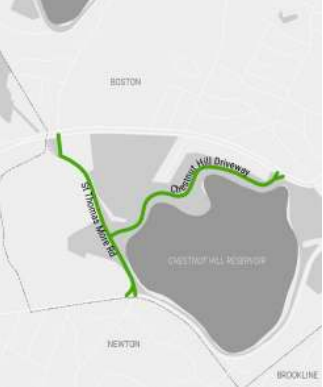
Chestnut Hill Driveway
Issue: Along the length of the corridor, there are no bicycle accommodations, there is cut through traffic, and there is parkland bisected by roadways. Recommendation: “As a short-term measure, lower the speed limit to 20 mph and consider adding traffic calming measures. Consider implementing advisory bike lanes. As a long-term strategy, consider the desirability and feasibility of closing Chestnut Hill Driveway to through vehicle traffic. Access could be maintained from either end up to the parking area.”
Saint Thomas More Road
Issue 1: Along the length of the corridor, there are no bicycle accommodations and there is cut through traffic. Recommendations: “Install bicycle facilities. Standard bike lanes are feasible. Consider implementing advisory bike lanes.”
Issue 2: Along the length of the corridor, there are infrequent opportunities to cross the parkway. Recommendations: “Enhance existing crosswalks and add new crosswalks at locations.”
Issue 3: Along the intersection of Canpanella Way (North), there are long crossing distances and a lack of accessibility. Recommendations: “Tighten intersection geometry, shorten pedestrian crossing distances, and provide accessible crossings.”
Conclusion – Page 227
“The DCR Parkways have been evolving since the first were planned in the late 1880s. This Plan represents a continuation of this evolution, serving as a guide to ensure the over-100 miles of parkways will be a safe, comfortable, and connected network of walkways and bikeways for people of all ages and abilities to access recreational destinations and healthy transportation options.
The recommendations in this Plan identify the opportunities for DCR to focus on in order to allow its parkways to meet this vision. Short-term recommendations identify improvements that can be added to repaving activities or placed in the five-year capital plan. Opportunities to redesign and reconstruct parkways to meet the Complete Streets standards are found in long-term recommendations. Maintenance, policy, and design recommendations provide guidance for all parkways to improve conditions for users of all mode types, ages, and abilities.
DCR will continue working with stakeholders, advocates, affected communities, and the general public as it implements the recommendations in the DCR Parkways Master Plan.”
Next Steps
Community members will have many opportunities to provide feedback, when the items become projects, throughout the DCR public process. If there are any particular concerns outside of an ongoing public process, you can email mass.parks@mass.gov.