
When are we going to repave Belmont Street and Trapelo Road?
The project took a decade to get underway, but it finally started last fall. The contractor is working through the winter installing new storm drainage grates and piping. The goal for 2014 is to complete paving from the Waltham line to the west side of Cushing Square. The goal for 2015 will be to complete paving through Cushing Square to the Cambridge line.
How much will the construction project cost?
The total costs are roughly $22 million. The construction contract value is $17.1 million, and an additional roughly $2 million in costs will be incurred for temporary removal of the catenary wires for the buses. State and federal agencies are paying these project costs. In addition to the state-federal project costs, the town of Belmont has spent roughly $3 million on design and subsurface infrastructure replacement (water, sewer, storm drains) along the corridor.
Who is running the project?
The state Highway department is overseeing the project. They have an engineer stationed full time on the site. The contractor is Newport Construction.
Who designed the project?
The state will be following a design blue-print developed and exhaustively vetted by the Town of Belmont in consultation with state engineers and with the town of Watertown. The town employed the BSC Group as consulting engineers. Peter Briere is the lead engineer for the project at the BSC Group. BSC’s design implements detailed conceptual direction provided by Belmont’s Traffic Advisory Committee based on public comment.
What does the design call for?
The project is a complete redesign of the streetscape all across the public right-of-way, including the sidewalks.
- The traffic flow will be channeled to two lanes and the sidewalks will be widened where possible.
- Where volume and turning motions call for additional lanes at signalized intersections, there will be three or four lanes as needed.
- Bike lanes will be striped for the entire length of the project.
- Over 200 new trees will be planted over the length of the corridor.
Are they pulling out the old trolley tracks?
No. The consulting engineers, working with the pavement experts at MassHighway made an early determination that the road bed underlying Trapelo Road is actually quite sound. They made that determination after taking core samples and fully inspecting the roadway. Of course, the pavement itself is badly worn and the tracks are coming through in places, but that pavement failure reflects several decades of low maintenance and is not indicative, in their opinion, of a failing road bed. Roads need to be maintained much more often than the corridor has been maintained.
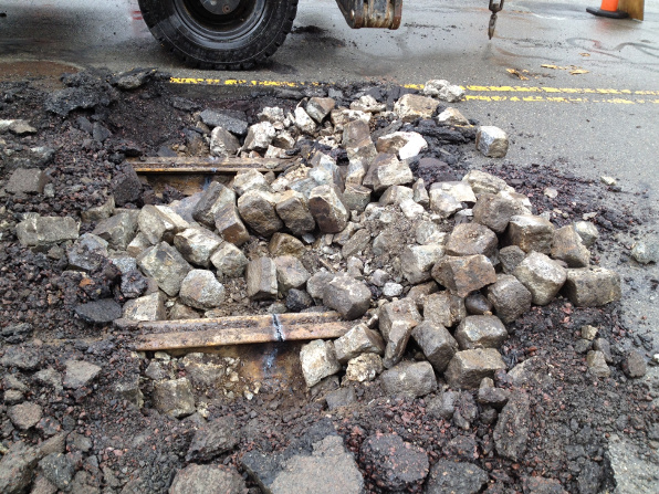
But what about the railroad ties — won’t they rot? And what about the rails themselves — will they rust and expand?
Certainly, to some degree, but the old track assembly is encased in concrete and cobble stones and the engineers feel that the whole assembly actually constitutes a strong road bed component. According to the engineers, there will be at least 3.5 inches of asphalt over the tracks when the final repaving is complete. Just a comparison data point: The photo below shows the dense packed cobble stones around the tracks underneath Huron avenue — Cambridge is tearing up those tracks to allow pipe installation below them. According to the workers in the field, the the ties in the layer below are 99% solid.
Why are they running diesel buses on the 73 line?
The presence of overhead catenary lines would force the contractors to use expensive special equipment to stay below them. The initial bids for the project came in too high because the catenary lines were not initially to be removed. After considerable negotiation, a new plan was worked out for temporary use of diesel buses during the project. When the project is complete, the catenary lines will be re-installed and the trolley buses will return.
Why has service deteriorated on the 73 line?
Many riders feel that the service has noticeably deteriorated, although a few disagree. My office is working with the MBTA to find out what’s happening with that.
Where can we see the detailed design plans for the project?
Plans are available by clicking here. There is also a massive blueprint book available for inspection at the office of the Town Engineer in the Belmont Town Hall annex.
Can we change the plans at this stage?
The field engineers will always work with homeowners or businesses along the street to tweak details if they can, but the basic plan is pretty much locked in.
Are existing trees being protected in the project?
In principle yes. We’ve been disappointed that the contractor has piled stones under the canopy area of the trees in front of the Waverley Oaks housing. That is a contract violation and we are working to address it.
Answer posted on November 12, 2015: The islands between Waltham and Cushing Square are in their final form — some actual raised islands with plantings; some flush concrete segments that serve to alert motorists to the raised islands. From Cushing Square to Cambridge, the islands are not in their final form. There will be a total of 5 raised islands with grass and plantings (a total of approximately 25 trees) between Cushing Square and Payson Road. Motorists will be alerted to the raised segments by scored concrete segments (flush to the asphalt). The two longest raised segments will be between Oakley Street and Payson Road. Between Cushing Square and Oakley Street, there will be three smaller raised islands.
Comments are closed.
What is the reason for taking two seasons (2014 and 2015) to pave a few miles of road? Couldn’t it have been done in a single season by doing more work in parallel? Speeding up the work would reduce the overall disruption significantly and bring the project to fruition sooner.
In general it seems that if we undertook fewer separate projects simultaneously but completed each one more quickly we would have fewer tie ups and more construction-free travel at any given time.
Kiril
If it were just paving, I think it could definitely get done in one season. But two years doesn’t bother me for a project that redoes drainage and redesigns the whole streetscape. It’s not just a question of resource allocation — it’s also about how much disruption the community can take all at once.
Did the timed traffic lights (to facilitate smooth rush hour traffic inbound in morning and outbound in evening) make it into the final design? It is important to keep the traffic moving, particularly inbound in morning, otherwise it will make the bus service deteriorate. Also, timed traffic signals encourage everyone to move at a moderate speed, safer than the current situation.
Thanks for the update Will. Aside from your looking into the project the past few months, there have been no updates on the project posted anywhere (except the ground-breaking ceremony which is only PR). Will there be a schedule of work, especially road disruptions, posted anywhere? The Town’s website on the project has not been updated in a while. I think it is important to communicate the work for both commuters and residents. When they removed the trolley lines, the street was closed off for a short while, yet there was no notice that this was going to happen. I hope that the Town and contractor will be more transparent in the future on the schedule and progress.
Bill, let me check on the light timing issue.
Yes, Matt. I understand that the Town Engineer has been trying to get time to posting a schedule. There is, of course, a project plan, but it’s not in a user-friendly format.
Will there be a commitment to proper maintenance in the future? It seems that so many of our infrastructure problems are due to woefully inadequate maintenance. It doesn’t seem to matter if the economy is good or bad – there are never enough funds allocated.
Fair point — maintenance is critical.
Maintenance will be the responsibility of the town of Belmont.
Belmont has done better at maintenance in recent years — there is a recognition among many town leaders that annual investment in capital maintenance is essential.
Regarding Trapelo Light timing, this from Glenn Clancy, Belmont’s Town Engineer:
In other words, the answer is yes — the timing should be good down the corridor.
Here is a further reply and clarification on the light timing issue from the engineer directly involved in the analysis of the light patterns.
Light timing is always a balancing act between competing flow priorities.
One last further clarification from the Town Engineer:
As was previously pointed out, it’s not an easy thing to optimize traffic flow along most stretches of Trapelo. On-demand lights and walk signals that actually stop traffic pretty much guarantee that flow will be difficult to optimize. I’m all for traffic management, but this project – especially if it constricts the road to two lanes – may not end up helping traffic flow (and will perversely attract more vehicles should it succeed). With two lanes, even parking a car on Trapelo will impede traffic. Developments in the works will generate additional journeys. So we’ll probably end up with a less bumpy ride that may take longer.
Actually, we really think that the project will improve flow. The design is for a basic two lane flow, but includes extra lanes where needed to accommodate turning movements, etc.
One thing that can help traffic signal synchronization and make a street more appealing for walking at the same time is to make the pedestrian signals automatic. This allows the timing between all the signals to be predictable and can allow them to be more easily coordinated for steady traffic flow. Pedestrians don’t have to press a button and wait, and traffic flows smoothly through synchronized green lights.
And while exclusive pedestrian phases are technically safest for pedestrians, they also make people wait longer and take time away from traffic. The town may want to consider concurrent signals that allow people to cross while parallel traffic has a green light. A short 3-5 second LPI (leading pedestrian interval) can be added to give pedestrians a head start before traffic is moving in that direction. Something to think about to increase traffic flow and increase convenience for pedestrians…
Thank you, Charlie. I’ll draw this comment to the attention of the town engineer. I’m not sure how the currently plannned timing squares with this comment. This is a thoughtful comment. We probably need to live into the newly redesigned road a little and see how things work before changing plans. But we’ll stay on it after the redesign is in place to keep tweaking it for the better.
From the Town Engineer, commenting on Charlie’s post above:
Nearly every intersection in Cambridge has a three second LPI (5 seconds in Central Square). While it is a slight impediment to traffic, it is a dramatic improvement for bicyclists and pedestrians. It is also something that can be tested and changed: it should be tried and measured to see if it actually increases travel times for vehicles.
I know about that delay — I do like it. This is something we can work on as we get the lights in place and get some real field experience on how the pedestrian and through traffic flows are working together.
Thanks Will for passing along my suggestion. I understand what the Town Engineer is saying, however if my understanding is correct, making the pedestrian signals concurrent in addition to automatic should have little effect on traffic flow since cars always have a green in one direction or another (as do the pedestrian signals), except of course during any short LPI phases.
It’s not necessarily the case that there are pedestrian Walk signals when the parallel flow is green. Many intersections protect pedestrians from turn movements by having an exclusive pedestrian walk phase. There are lots of options and we can definitely experiment further after the construction is complete.
Why is a contractor from New Hampshire doing the work. This is a Massachusetts funded project.
In short, they submitted the best bid. We don’t limit bidding to Massachusetts contractors. There is a long conversation to be had about unfair tax advantages that a contractor from New Hampshire may or may not have. But that’s a different issue. The basic principle is to get the best value.
Our office received an inquiry about the bus shelter plans for the Trapelo Road Project. I received the following information from Glenn Clancy, Belmont Town Engineer:
Bus Shelter Location Plans
Bus Shelter Design
Andrew Bettinelli
Legislative Aide
Office of State Senator William N. Brownsberger
The lane painting appears to be complete between Waverley Oaks Rd and Pleasant St yet there are no bike lanes?!
Are these coming later?
Every planning document I’ve seen including this page discusses bike lanes and I’m not seeing them on the road.
I posed your question to Glenn Clancy, Town Engineer for Belmont:
So, the short answer is: yes, the bike lanes will be included at a later date.
Andrew Bettinelli
Legislative Aide
Office of State Senator William N. Brownsberger